What is a Comprehensive Plan?
A Comprehensive Plan defines the vision, goals and aspirations for the long-term development and redevelopment of the community. The plan is intended to shape land use and transportation patterns, conserve natural resources, and identify needs for utilities, housing and parks and open space. The Comprehensive Plan also guides decisions on both public and private investments in infrastructure and facilities.
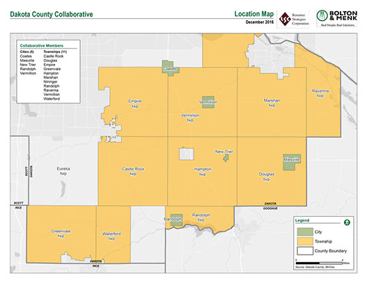
The Dakota County Township Officers’ Collaborative Comprehensive Plan will address the following:
- Future Land Use
- Housing Needs
- Natural Resources
- Transportation
- Public and Individual Utilities
- Parks and Trails
- Economic Opportunities
Why Update the Comprehensive Plan?
State law requires all cities, townships and counties in the 7-county metropolitan area update their Comprehensive Plans at least every 10 years. Local plans must align with the Metropolitan Council’s regional system plans related to highways, transit, airports, wastewater services, parks and open space. Rather than undertake this effort separately, since 1999 the members of the Dakota County Township Officers’ Collaborative have chosen to participate in a joint planning process and develop a single comprehensive plan. This process allows the members of the Collaborative to pool their resources and develop a comprehensive plan meeting the requirements of the state law. At the same time, each community is provided with an “addendum” highlighting its unique features and issues. The current Comprehensive Plan for the Collaborative communities was completed in 2009.
Process and Schedule
- In general, the process includes:
- A series of investigations and evaluations to fully understand existing conditions, issues, and trends.
- An analysis of population, housing and economic data based on historical trends, and recent projections.
- An evaluation of existing land use categories and definitions.
- An analysis of housing needs, and a community’s allocation of affordable housing, if applicable
- A review of existing plans for the technical elements including transportation, water resources, parks and trails, and utilities.
- Draft goals and objectives, and policies and strategies to implement the Plan.
The Collaborative has hired the consulting team of Resource Strategies and Bolton & Menk to complete the update. The team will meet at least three times with each community over the next 18 months.
The Draft Comprehensive Plan for the Dakota County Collaborative and the Individual community plans were submitted to the Metropolitan Council for official review on December 31, 2018. The Metropolitan Council is currently reviewing and commenting on the plan. Once comments are received and necessary edits are made, collaborative communities will adopt the comprehensive plan. Adoption of the plan in each community is anticipated sometime in Spring 2019.
Individual Comp Plans by Community
Land Use Maps
Existing Land Use
Castle Rock Township
City of Coates
City of Miesville
City of New Trier
City of Randolph
City of Vermillion
Douglas Township
Empire Township
Greenvale Township
Hampton Township
Marshan Township
Nininger Township
Randolph Township
Ravenna Township
Vermillion Township
Waterford Township
Future Land Use
Castle Rock Township
City of Coates
City of Miesville
City of New Trier
City of Randolph
City of Vermillion
Douglas Township
Empire Township
Greenvale Township
Hampton Township
Marshan Township
Nininger Township
Randolph Township
Ravenna Township
Vermillion Township
Waterford Township

